Source: Professor Jan Nyssen
Professors Shiferaw Bekele and Dagnachew Assefa of Addis Ababa University (AAU) have stated that the maps produced in our publication “Western Tigray in 109 historical and 32 ethno-linguistic maps (1607-2014)” have been “doctored”. I have reached out to both professors, asking them which maps would have been doctored, but so far I did not receive their reply.
The historical and language maps of Western Tigray speak for themselves, there is no need to “doctor” them
A rebuttal to Professors Shiferaw Bekele and Dagnachew Assefa (Addis Ababa University)
by: Jan Nyssen, em. Professor of Geography, Ghent University, Belgium
Date: 24 April 2023

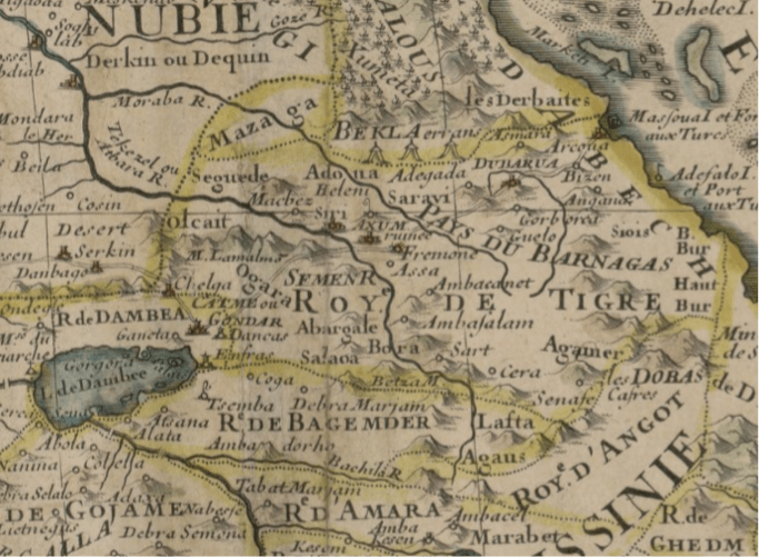
Fig. 1. Excerpt of a map of the Horn of Africa (de L’Isle 1707). After the original copy preserved at the Library of Congress (https://www.loc.gov/item/2021668731/)
Two professors of Addis Ababa University (AAU) have stated that the maps produced in our publication “Western Tigray in 109 historical and 32 ethno-linguistic maps (1607-2014)” (Nyssen 2022) have been “doctored”. On 13 April, the Andafta YouTube channel posted a video, which has received more than 100,000 views. It holds a one-hour interview with Professor Dagnachew Assefa, in Amharic. In the interview, Prof. Dagnachew brings up our work and quotes its evaluation by Prof. Shiferaw, an emeritus Professor of History at AAU: “For example, Professor Shiferaw Bekele told me there is one known professor who is insidious. He is called Professor Jan Nyssen, Ghent University, Belgium. This man takes maps, doctors them, changes them and changing some of the narratives, in a very careful manner. He [Professor Shiferaw] has sent me the maps, where he [JN] has changed them, he [JN] is doing his work.” Hence, the conclusion of the work, i.e., that the claims of long-standing Amhara dominance over Western Tigray (Welkait and surrounding districts) are not supported by historical facts, would be based on “doctored” maps. Let us see the accusation in detail and revisit the historical maps.
Interview context
When discussing interview statements, they should be placed in the context of the interview. The Andafta interviewer introduces Prof. Dagnachew as a professor of philosophy at Addis Ababa University. Dagnachew starts his talk by stating how lucky he was to have a conversation with professor Shiferaw of Addis Ababa University on the subject of Amharas. He says he learned from the professor about the dangerous framing of the Amharas as expansionists, oppressors and land grabbers starting with the Italians and that this is still continuing. He says the Eritrean liberation fronts did it, the Ethiopia Student Movement accepted it and now the Tigrayans and the Oromos are doing it in a coordinated manner and the Welkait and Raya issue are also being seen within this framework. He adds Tigrayans and the Oromos have also brought foreigners onboard on this subject and then brings me up saying that professor Shiferaw told him about myself and my work (see from minute mark 13):
“For example, Professor Shiferaw Bekele told me there is one known professor who is insidious. He is called professor Jan Nyssen, Ghent University, Belgium. This man takes maps, doctors them, changes them and changing some of the narratives, in a very careful manner, he [Professor Shiferaw] has sent me the maps, where he [JN] has changed them, he [JN] is doing his work. A coordinated work is being done. On one hand Amharic vilification and painting the Amharas as devil, and on the other hand “the land is Tigrayan” has already started.”
Prof. Dagnachew goes on to say there are more works from others too and says there are different levels of involvement of experts, historians and geographers and that such work is not being done on the Amhara side. But he mentions there is one amazing concept note of 60 pages brought to him and others by Fasika. He says it is on Welkait and Raya and it has an amazing content on especially Welkait and adds that they are working to translate it to English and French. He concludes this section by saying that the Prosperity Party leadership is also accepting the narrative (minute 17 into the video).
The interview goes on, and Prof. Dagnachew mentions chatting with many other people (Mesay Kebede, Yonas Birru and so on), the intellectual roots of the campaign on Tigray. In the whole video no effort is even done anymore to camouflage the anti-Tigray campaign as “law and order against terrorist TPLF.” Dagnachew cites conversations that he had with many “Amhara intellectuals.” This makes us to believe that Dagnachew really had a conversation with Shiferaw where these things have been said.
Lastly, the interview gives many clues on the relations of the Amhara elites with Abiy and why they supported him (and still support him). He said, their relationship with Abiy was for a specific purpose; clearly for the war on Tigray, as deduced from the context of the conversation. He also says they will continue to do so for other similar reasons.
None of the compiled 141 historical and language maps of Western Tigray has been “doctored”
Obviously, the interpretation of these maps might be debated, as these are complicated artifacts that do not immediately match to the reality they purport to reflect. Every map might be the subject of its own in-depth investigation. A map’s portrayal is always a combination of hard facts, perception, power dynamics, territorial claims, misinformation, and temporal lag. Until aerial photographs were realized in the 1930s (Nyssen, Petrie et al. 2016), the representation of the vast Ethiopian highlands was perceptually distorted by factors of strangeness and remoteness, paraphrasing (Kraak and Ormeling 2011). In a nutshell, the historical maps are products of their period.
That is why, in a first instance we favored a meta-analysis. The maps examined in this meta-analysis are genuine documents that have not been altered in any way. The advantage of our approach is that we analyze all maps accessible, rather than only those that fit with one narrative, as Achamyeleh Tamiru (2019) did with his selective adoption of documents.
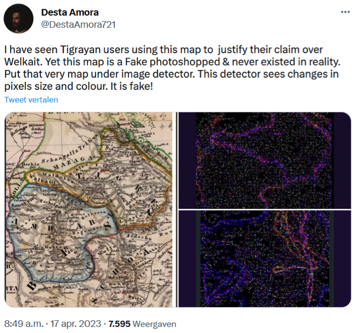
Fig. 2. Example of fake map claims on social media (https://twitter.com/DestaAmora721/status/1647854764338696192)
Since the publication of the first version of our dataset of maps, there has been a social media campaign stating that we doctored the maps, adding lines and colors. The evidence produced by the maps is so overwhelming that this remained the last option for those claiming “ancestral Amhara ownership” of Western Tigray (Fig. 2).
If somebody doubts that the colored lines on (Handtke)’s map, displayed in Fig. 2, are part of the original map produced in 1849, they can consult the copies held at Estonia’s national library (https://www.digar.ee/arhiiv/nlib-digar:429790) and at the David Rumsey Center at Stanford University (https://www.davidrumsey.com/luna/servlet/detail/RUMSEY~8~1~33543~1171029:Composite—NO-Afrika-). The map has also been chosen by Haggai Ehrlich for the cover of his upcoming book “Greater Tigray and the Mysterious Magnetism of Ethiopia.”
We understand that it is an easy trick on social media to spread the disinformation that maps have been faked. But when university professors hold the same language, this becomes problematic. For instance, I want to draw the attention of Prof. Shiferaw to the map produced by Guillaume de L’Isle in 1707 (Fig. 1). Isn’t “ROY.e DE TIGRE” written across the full extent of the current Tigray, from West to East? Does he see its borders in dark yellow color, showing that the “Kingdom of Tigray,” at the time and according to this map, included “Olcait”? Similarly to cartographers Bonne (1782) and Cassini (1798), de L’Isle (1707) mapped Tigray’s southwestern border close to Chelga (= Aykel) and Emfraz, two towns that are west and southeast of Gondar. Would Prof. Shiferaw then think that these yellow lines have been added by an insidious Belgian professor, as part of a large faking industry set up by Tigrayans and Oromos? No, just check the original map held at the Library of Congress (https://www.loc.gov/item/2021668731/).
Challenge for Professors Shiferaw and Dagnachew
I have reached out separately to both professors on 17 April 2023; to date, neither of them has replied. Prof. Shiferaw, for instance could have stated that his words had been misinterpreted, but he did not. So we must conclude that both of them have claimed that I, as a geography professor, am “doctoring” historical maps and thereby falsifying facts. This is a serious accusation of fraud, and I have defied Professors Shiferaw and Dagnachew to bring the evidence that these maps of Western Tigray have been “doctored”. Or even show us just one “doctored” map among the full set of 141 maps? In absence of such evidence, the conclusion of our meta-analysis stands strong: “Historical cartography demonstrates that claims of long-standing Amhara dominance over Western Tigray (Welkait and surrounding districts) are not supported by historical facts and are therefore based on sand” (Nyssen 2022).
Acknowledgments
Thanks to Gebrekirstos Gebremeskel (Tghat and CWI, The Netherlands) and Teklehaymanot G. Weldemichel (NTNU, Norway) for listening to the full interview, summarizing, translating and transcribing it. Gebrekirstos and Teklehaymanot, as well as five other colleagues, are also appreciated for exchanges of thoughts on the statements produced in the interview.
References
Achamyeleh Tamiru (2019). የወልቃይት ጉዳይ (The Wolkait Affairs). Stockholm, Self-published.
Andafta (2023). የጃዋር አዲሱ አሰላለፍ እና ለዶ/ር አብይ የምሰጠው አንዲት ምክር | የአማራ ህዝብ ቀጣይ ስጋት | Dr Dagnachew Assefa | Ethiopia. Andafta YouTube Channel. Addis Ababa.
de L’Isle, G. (1707). Carte de l’Egypte, de la Nubie, de l’Abissinie. Paris.
Ehrlich, H. (2023). Greater Tigray and the Mysterious Magnetism of Ethiopia. London, Hurst.
Handtke, F. H. (1849). Nordöstliches Afrika. Supplement-Band zum Hand-Atlas der neueren Erdbeschreibung. K. Sohr. Glogau/Głogów and Leipzig, Flemming.
Kraak, M. J. and F. J. Ormeling (2011). Cartography: visualization of spatial data. New York, Guildford Press.
Nyssen, J. (2022). Western Tigray in 109 historical and 31 ethno-linguistic maps (1607-2014)[Dataset], Zenodo https://zenodo.org/record/7007604. Nyssen, J., G. Petrie, Sultan Mohamed, Gezahegne Gebremeskel, V. Seghers, M. Debever, Kiros Meles Hadgu, C. Stal, P. Billi, P. Demaeyer, Mitiku Haile and A. Frankl (2016). “Recovery of the historical aerial photographs of Ethiopia in the 1930s ” Journal of Cultural Heritage 17: 170-178.

An excellent scientific work. Z so called ethiopian professors (dagnacgew and shiferaw) and youtubers do not have z knowledge and courage to argue with prof. J. Nyssen. The are just biased propagandists. They are blind supporters of z expantionists and landgrabbers. They were blindly supporting z war waged on Tigray just for z sake of stealing z historical and constitutional lands of Tigray
I am a PhD student in UK and I am welketay by identity. In fact, the people of welkayt called themselves ” welketay/welkaytie”. The political elite in both ethnic group (Amhara and Tigray) are expansionist and land grabbers. We do not have an issue related with language. Whilst the people bordered with the Amhara region speak amharic primarily, those bordered to Tigray speak Tigrigna. I can say we speak both languages with our own accent. Both Amhara and Tigrian politicians dream to create thier own homogeneous society. Despit this, we call ourselves welketay/welkaytie, with regards to identity. The TPLF has tried to change the demography of welkayte people through resettlement programs while cleansing the welkayte people on the other hand. TPLF has commited Genocide on the people of Welkayte. If you are a man, dig hard for the truth and stand with the voiceless people of welkayte. That is what a man of character does.
You are not from welkaite, simply you chatting in the name of welkaite, Welakite never be hesitating their identity. They speak Tigrigna, their areas all known and having Tigrigna.
An excellent scientific work. Z so called ethiopian professors (dagnacgew and shiferaw) and youtubers do not have z knowledge and courage to argue with prof. J. Nyssen. The are just biased propagandists. They are blind supporters of z expantionists and landgrabbers. They were blindly supporting z war waged on Tigray just for z sake of stealing z historical and constitutional lands of Tigray
In our country ethiopia…ethinicity and acadamic honour becames corupted for longer than 30 years…professorship and doctrate simply provided ethinic based,,,look,wolkayit and raya has umbgouis history above he stated,he simply mentioned the idea tplf,,,,his doctrate should be acused and take proper actions!!
Thank you guys for the effort you are exerting to make disputed geagraphic locations as clear as possible and gives ordinary people to have a choice of working to understand more rather than taking shallow articles and propaganda at their face value
Medhin
Ethiopia is an indepent, sovereign, never colonized nation , so that Ethiopia has a right to divide its Administration region in such away which helps the people’s of Ethiopia
let us keep away from a narrative that Ethiopian unity is a contractual Agreement
Thank you JN for the historical facts and appreciate your work and follow up to expose misinformation. Arguing based on facts and analysing the information with out any bias is the minimum requirement of high level academicians. It is only when they do this they could be different than the ordinary activists and u-tubers.
Wolkayities are people with multi lingual identity. They both speak Amharic with their Gondor border, Arabic with Sudanese and Tigrigna with Tigray &Eritrean neighbors. Don’t try to give a new identity against the people’s interest. No map or old aged parchement will decide on the fate of Wolkayitie rather only the original people who lived there.
https://tghat.com/2023/03/28/western-tigray-a-tigrayan-territory-since-antiquity/?amp=1l
#AmharaOutOfTigray
A book written by Rev. Michael Russel, a history of Abyssinia and Nubia (1833)
It is clearly indicate the Amhara and Tigray territory, every concerned body can read it on pages from 91-121